HARNESS THE POWER OF ArcGIS® WITH CYNERGE AS A


Bronze Level Partner
As a proud Bronze Level Partner with Esri since September 2023, we leverage our extensive expertise to deliver exceptional geospatial solutions. Our partnership with Esri underscores our commitment to utilizing cutting-edge technology to meet the diverse needs of our clients. While our official partnership began recently, our team has been providing geospatial services for much longer, building a strong foundation of knowledge and experience.
Visit Our Esri Partner PageExtensive Experience
With over 65 years of combined experience in the geospatial industry, our team excels in a wide range of Esri products and services, including the following:
ArcGIS® Enterprise
We specialize in deploying and managing ArcGIS Enterprise for you, ensuring seamless integration and optimal performance for your organization’s geospatial infrastructure by designing for high availability and scalability in cloud-native, on-premises, and hybrid deployments.
ArcMap to ArcGIS Pro® Modernization
We guide clients through the transition from ArcMap to ArcGIS Pro, offering comprehensive modernization services that include data migration, workflow optimization, and training.
ArcGIS® Online
Our experts are adept at harnessing the power of ArcGIS Online to create dynamic, interactive maps and applications that enhance data visualization and decision-making. In addition, we are experts in the administration and configuration of ArcGIS Online.
Esri ArcGIS Pro Desktop
Our expertise in the Esri ArcGIS Pro Desktop geoprocessing framework including ModelBuilder and Python allows us to deliver customized solutions that meet your unique geospatial needs.
Maps and Visualizations
Explore our portfolio of maps and visualizations to see our capabilities in action. These examples showcase the innovative solutions we’ve developed using Esri technology.
Watershed Analysis Results
This graph highlights our expertise in spatial analysis, workflow development, and digital elevation model processing using Esri’s ArcGIS Pro and ModelBuilder. These advanced GIS tools are essential for conducting comprehensive watershed analysis, showcasing our proficiency in leveraging cutting-edge technology for environmental management.
Watershed Analysis Site Suitability Analysis – Unique Categories
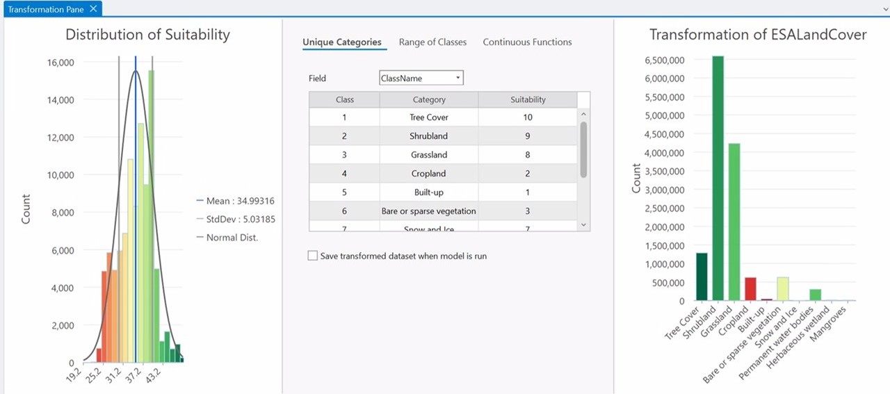
This image illustrates the classification of a land cover dataset using a unique category classification system. This classification is integral to site suitability analysis, providing detailed insights into various land cover types to support informed decision-making for projects such as development and conservation.
Watershed Analysis Site Suitability Analysis – Continuous Functions
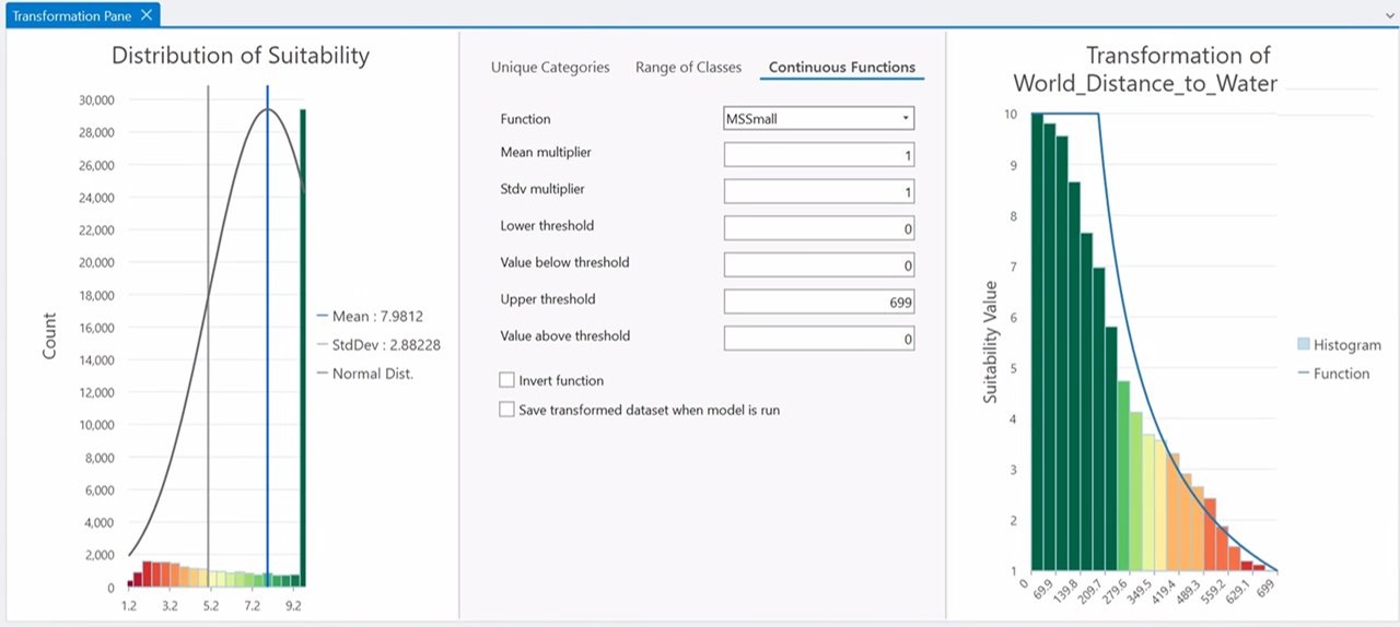
This image depicts the classification of a distance to water dataset using a continuous function classification in Suitability Modeler within ArcGIS Pro. This classification is crucial for site suitability analysis, providing a detailed gradient of proximity to water sources to inform decisions on land use and development.
Watershed Analysis Results
This graph highlights our expertise in spatial analysis, workflow development, and digital elevation model processing using Esri’s ArcGIS Pro and ModelBuilder. These advanced GIS tools are essential for conducting comprehensive watershed analysis, showcasing our proficiency in leveraging cutting-edge technology for environmental management.
Travel Time Analysis
This image illustrates a travel time analysis conducted using Esri ArcGIS Pro and ModelBuilder™. The analysis supports business decisions by evaluating potential office, retail, or wholesale sites based on accessibility and travel times. Key factors such as traffic patterns and site comparisons are visualized to determine the most suitable locations.

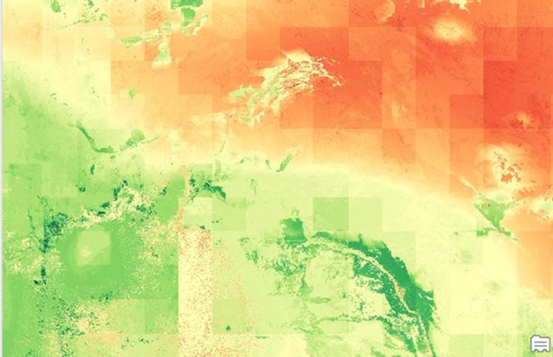
Watershed Classification and Analysis

This image demonstrates the use of Esri ArcGIS Pro, ModelBuilder, and Suitability Modeler to determine land use and land cover composition. This analysis supports watershed management by providing detailed insights into the landscape, helping to identify areas for conservation, development, and resource management.
Comprehensive Assessments and Recommendations
We conduct thorough assessments of your current geospatial systems and workflows, identifying areas for improvement and providing actionable recommendations. Additionally, we specialize in implementing new GIS solutions, introducing and establishing advanced geospatial technologies to enhance your operational efficiency and decision-making capabilities. Our goal is to help you maximize the value of your geospatial investments and achieve your strategic objectives.
Solutions
Server
On-Premises ArcGIS Enterprise Installation and Configuration
Our experts handle the entire process of installing and setting up the ArcGIS Enterprise system within your secure, on-premises firewalled network. From planning to final implementation, we ensure a smooth and efficient process. We customize the setup to meet your specific needs and security requirements, providing you with a reliable system tailored to your requirements.
ArcGIS Enterprise High Availability and Disaster Recovery Architecture Designs
Enhance your system’s performance and reliability with our extensive expertise in cloud architecture and ArcGIS Enterprise design. We specialize in creating highly available ArcGIS Enterprise deployments that surpass the basic out-of-the-box Esri HA/DR capabilities. Our tailored solutions ensure your system is robust, resilient, and capable of meeting your unique operational requirements, offering you peace of mind and optimal performance.
Geospatial Big Data Architecture Solutions
Manage large volumes of geospatial data efficiently with our support. We develop analytical workflows tailored to your specific needs, helping you process and analyze data effectively. We also focus on optimizing storage costs, ensuring cost-effective data storage without compromising performance. Streamline your data management processes, gain valuable insights, and make informed decisions that drive your success.
Online
Custom ArcGIS Application Development
Our skilled geospatial architects create custom applications that integrate seamlessly with ArcGIS Enterprise. We work closely with you to understand your unique requirements and develop solutions that enhance your geospatial capabilities. Whether you need applications for data visualization, spatial analysis, or workflow automation, our developers ensure the applications are tailored to meet your specific needs. Maximize the potential of your ArcGIS Enterprise system and achieve your operational goals efficiently.
ArcGIS Enterprise and ArcGIS Online Administration and Management
Alleviate the administrative burdens of managing ArcGIS Enterprise and ArcGIS Online with our support. We handle user management and troubleshooting to ensure your geospatial systems run smoothly and efficiently. Partnering with us reduces the time and effort needed to find and hire specialized staff, leading to cost savings and increased productivity. Enjoy a hassle-free experience and leverage the full potential of your ArcGIS systems without the administrative overhead.
AWS and Azure ArcGIS Enterprise Installation and Configuration
Our experts specialize in installing and configuring the ArcGIS Enterprise system in the cloud, with a focus on GovCloud. We ensure a seamless and secure setup tailored to meet the stringent requirements of government cloud environments. Our services include comprehensive planning, precise configuration, and ongoing support to ensure your system operates efficiently and securely. Confidently deploy ArcGIS Enterprise in GovCloud, knowing your data is protected and your system is optimized for performance. We provide a reliable and robust solution that meets your specific needs.
Desktop GIS with ArcGIS Pro
Geospatial Modeling and Workflow Development and Automation
Streamline your geospatial analytical workflows using Esri’s ModelBuilder and Python with our collaboration. We understand your specific needs and challenges, ensuring the solutions we develop are tailored to your unique requirements. We assist in designing, building, and optimizing workflows that enhance efficiency and accuracy in your geospatial data analysis. Automate repetitive tasks, reduce manual effort, and improve overall productivity with our support. Achieve your objectives with ease through a seamless and efficient workflow.
Aerial Imagery, Terrain, and Full Motion Video Data Collection
Capture high-resolution imagery and terrain data with our assistance, ensuring you get the most accurate and detailed information possible. We use advanced technology and techniques to gather precise geospatial data tailored to your specific needs. Whether you require imagery for mapping, analysis, or planning, we provide comprehensive support throughout the entire process. From initial data capture to final delivery, we ensure the highest quality results, enabling you to make well-informed decisions based on reliable and detailed geospatial information.